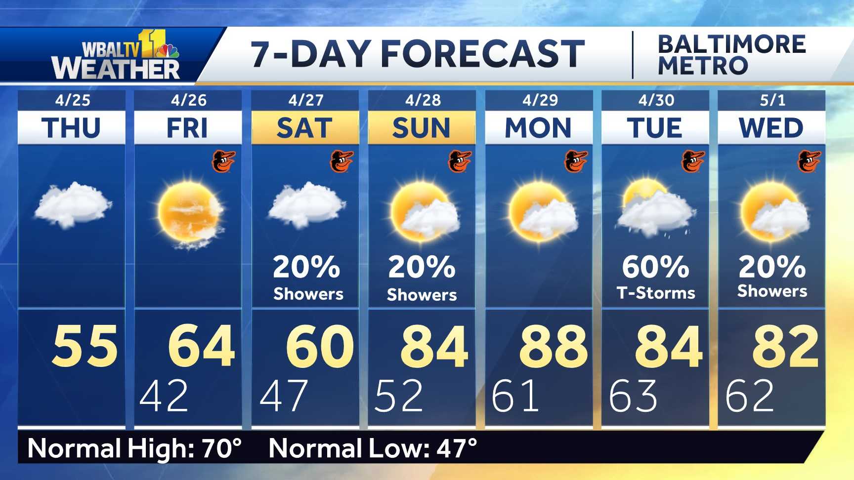
THE TIME NOW. 446. WE’RE GIVING YOU A LIVE LOOK AT CAMDEN YARDS. YOU CAN SEE IT’S A LITTLE BREEZY, BUT WE ARE EXCITED FOR THE GAME LATER TODAY. EVEN IF THERE IS A CHANCE FOR STORMS BY THE END. AND IF YOU WERE WATCHING BEFORE THE BREAK, WE WANTED YOU TO TRY TO GUESS WHO WAS THE FIRST OPENING DAY PITCHER WHEN CAMDEN YARDS OPENED. AND THE ANSWER IS RICK SUTCLIFFE. SO GOLD STAR FOR YOU IF YOU GOT THAT RIGHT AFTER BEING ACQUIRED THAT OFF SEASON, SUTCLIFFE WOULD PITCH A COMPLETE GAME SHUTOUT OVER CLEVELAND, ALLOWING JUST FIVE HITS. O’S WOULD GO ON TO WIN TWO NOTHING. LET’S GET SOME OF THAT ENERGY FROM THAT FIRST OPENING DAY FOR LATER TODAY. THE PROBLEM IS THERE’S A LOT OF ENERGY IN THE ATMOSPHERE AS WELL, AND THAT MEANS A CHANCE FOR STORMS. WE’RE UNDER A SLIGHT RISK. SO THIS YELLOW SHADING THAT YOU CAN SEE HERE, SLIGHT RISK THAT THE STORMS THAT FORM LATER TODAY WILL PRODUCE SEVERE WEATHER. AND THAT WOULD BE THE RISK OF DAMAGING WINDS, HAIL OR EVEN ISOLATED TORNADOES. BUT IT’S JUST A SLIGHT RISK THAT THEY TURN SEVERE. IT’S A VERY LIKELIHOOD THAT YOU ARE GOING TO SEE STORMS REGARDLESS LATER TODAY. TEMPERATURES ARE CURRENTLY IN THE 60S. IT FEELS SO MILD AND HUMID TO START OUT THE DAY, AND THAT’S HELPING TO SPARK A FEW SHOWERS ALREADY. THESE LIGHT RAIN SHOWERS ARE POPPING UP AROUND BALTIMORE, BUT THEY SHOULD TAPER OFF THROUGH ABOUT 7:00. OFF TO OUR WEST. THAT’S WHERE WE ALREADY SEE THUNDERSTORM ACTIVITY FORMING, AND THIS WILL ESPECIALLY GET GOING LATER TODAY WHEN THE ATMOSPHERE HAS SOME TIME TO HEAT UP. THE PROBLEM WILL BE ACTUALLY, IF WE GET SOME SUN BREAKING OUT MID ALWAYS EVERYONE THINKS, OH, IT’S SO PRETTY, THE SUN’S OUT. THE PROBLEM IS, ON A DAY WHEN YOU HAVE THUNDERSTORMS POSSIBLE, THAT SUN JUST ADDS FUEL TO THESE STORMS. IT JUST ADDS ENERGY TO THE ATMOSPHERE. IT’S ACTUALLY WORSE WHEN YOU SEE SUN BREAK OUT ON A DAY WHEN THERE’S A SEVERE WEATHER RISK. SO DEPENDING ON HOW MUCH SUN WE SEE, THAT WILL HELP DETERMINE JUST HOW VOLATILE THE ATMOSPHERE IS LATER TODAY. SEEMS LIKE WE’RE MAINLY DRY THROUGH ABOUT 3 P.M., SO THE ORIOLES SHOULD BE ABLE TO START THE GAME. OKAY, THERE’S ONLY A SLIGHT RISK STORMS WOULD BE POPPING UP BY THEN, BUT WE’RE GOING TO HAVE TO WATCH THE GAME VERY CLOSELY BECAUSE THROUGHOUT THE GAME, THUNDERSTORMS WILL BE DEVELOPING. THE TIMING SEEMS TO BE SLOWING DOWN, SO ALL THE BETTER THAT THEY PUSH THE GAME BACK TO OR PUSHED IT EARLIER IN THE DAY, BECAUSE IT SEEMS ESPECIALLY LIKELY TOWARDS SIX SEVEN AND 8:00. YOU’RE GETTING THESE THUNDERSTORMS POPPING UP, AND THAT’S WHEN PEOPLE ARE LEAVING THE GAME AND CELEBRATING. IN BALTIMORE, YOU WANT TO BE ESPECIALLY CAREFUL IF YOU HEAR ANY THUNDER. SO MOST OF TODAY IS DRY. THE SUN COULD BREAK OUT. MIDDLE OF THE DAY. WE’LL CLIMB ALL THE WAY INTO THE UPPER 70S, BUT WATCH THE LATE AFTERNOON AND EVENING FOR THAT CHANCE FOR STORMS. SO IT SEEMS LIKELY WE’LL GET TO START THE GAME. THE QUESTION WILL BE, WILL STORMS BE DEVELOPING TOWARDS THE END? EVEN IF WE GET THE FULL GAME IN, IT’S EVERYONE LEAVING THE GAME. WALKING BACK WHERE YOU WANT TO BE. ESPECIALLY CAREFUL IF YOU’RE WALKING THROUGH THE CITY AND HEAR THUNDER. I WOULD GO SAFELY INSIDE A BUILDING AND TRY TO WAIT IT OUT UNTIL THE RISK OF LIGHTNING HAS MOVED OUT OF YOUR AREA, SO JUST A GOOD IDEA TO BE PREPARED WITH THIS WEATHER TODAY. TOMORROW THE SUN IS BACK, THE BREEZE IS COOLER, WILL BE IN THE 50S. WEDNESDAY THE CLOUDS INCREASE. STILL WITH A COOL BREEZE BY THURSDAY, FRIDAY, SATURDAY AND SUNDAY WE HAVE SHOWERS IN THE FORECAST. THERE MAY EVEN BE SOME TH
Impact Weather as thunderstorms expected for O’s Opening Day

It will be an Impact Weather Day for Opening Day here in Baltimore as heavy rain and possible thunderstorms are possible. || Closings/Delays | Weather Advisories | Radar | Forecast | Email Alerts | Send us your pics ||Meteorologist Ava Marie says Monday will start with a few showers early before the clouds break for sun midday. The thunderstorms could develop anytime after 3 p.m. with them most likely from 5–10 p.m. Heavy rain and lightning is likely with a slight risk for damaging winds, hail, and isolated tornadoes. The Baltimore Orioles moved the start time of Monday’s home opener up to 2:35 p.m. due to storms in the weather forecast.It will be warm, humid and breezy with temps reaching the upper 70s. The winds will be steady and will have gust around 25 mph. The thunderstorms will turn into rain by the evening and the showers will taper off overnight to set up a clear but colder Tuesday. | LINK: MDOT SHA’s Statewide Transportation Operations Response Map Download the WBAL-TV app NOW and turn on push alerts to be aware of severe weather warnings, listen to NOAA Weather radio, and watch WBAL-TV 11 when impending severe weather develops.@wbaltv11 | @TTasselWBAL | @AvaWBAL | @TonyPannWBAL | @DalenciaWBAL | @AlenaLeeWXWBAL-TV 11 Maryland Weather RadarApp users tap here for interactive radar.Maryland’s 7-Day Weather ForecastAlert Days vs. Impact DaysYou may see the WBAL-TV 11 Weather Team highlight Alert Days or Impact Days in the forecasts. Here’s what that means:An Impact Day is when weather will likely disrupt your normal daily schedule or routine.An Alert Day is when there’s a threat of extreme, severe and possibly life-threatening weather.Potential power outagesStorm conditions could cause outages by knocking down tree limbs onto power lines and other electric delivery equipment. Baltimore Gas and Electric asks all customers to report their outage in any of the following ways: Online, at BGE.comBGE’s free mobile app, available at the Apple Store or Google Play Text message, to 69243 Phone, by calling 877-778-2222The latest outage information, including total number and general locations, is available on the BGE.com outage map.As a reminder, fallen overhead power lines should never be approached or touched even if the lines do not appear to be live or sparking. Call BGE at 877-778-2222 to report fallen electrical lines, power outages and gas odors.Share your weather photos and videosWhen and where safe, show us your weather photos and videos, we may show them on 11 News or online!DIRECT UPLOAD: Use this form to upload photos or video.EMAIL: Just email your photos and video to [email protected]: Severe weather alerts from the WBAL-TV app: step-by-step guideCLOSINGS: See if schools, businesses or organizations have closed or delayedRADAR: Track snow, sleet or freezing rain with WBAL-TV’s interactive radarROADS: Check for crashes and backups with our interactive traffic mapWINTER: Guide: Snow safety, driving hazards, power outagesTORNADO SURVIVAL: 5 things you need to do nowHURRICANE PREPARATION: How to prepare for hurricane season
It will be an Impact Weather Day for Opening Day here in Baltimore as heavy rain and possible thunderstorms are possible.
|| Closings/Delays | Weather Advisories | Radar | Forecast | Email Alerts | Send us your pics ||
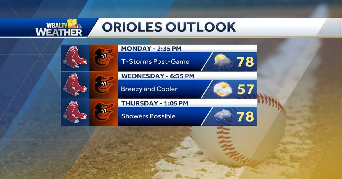
Meteorologist Ava Marie says Monday will start with a few showers early before the clouds break for sun midday. The thunderstorms could develop anytime after 3 p.m. with them most likely from 5–10 p.m. Heavy rain and lightning is likely with a slight risk for damaging winds, hail, and isolated tornadoes.
This content is imported from Twitter. You may be able to find the same content in another format, or you may be able to find more information, at their web site.
I have high hopes that the O’s will get in most, if not all, of the game today, before storms develop this evening. Here’s the forecast for the rest of the home opening series: @wbaltv11 pic.twitter.com/dcDsAxjdVL
— Ava Marie (@AvaWBAL) March 31, 2025
The Baltimore Orioles moved the start time of Monday’s home opener up to 2:35 p.m. due to storms in the weather forecast.
This content is imported from Twitter. You may be able to find the same content in another format, or you may be able to find more information, at their web site.
It will be warm, humid and breezy with temps reaching the upper 70s. The winds will be steady and will have gust around 25 mph. The thunderstorms will turn into rain by the evening and the showers will taper off overnight to set up a clear but colder Tuesday.
This content is imported from Twitter. You may be able to find the same content in another format, or you may be able to find more information, at their web site.
| LINK: MDOT SHA’s Statewide Transportation Operations Response Map
Download the WBAL-TV app NOW and turn on push alerts to be aware of severe weather warnings, listen to NOAA Weather radio, and watch WBAL-TV 11 when impending severe weather develops.
@wbaltv11 | @TTasselWBAL | @AvaWBAL | @TonyPannWBAL | @DalenciaWBAL | @AlenaLeeWX
WBAL-TV 11 Maryland Weather Radar
App users tap here for interactive radar.

Maryland’s 7-Day Weather Forecast
Alert Days vs. Impact Days
You may see the WBAL-TV 11 Weather Team highlight Alert Days or Impact Days in the forecasts. Here’s what that means:
- An Impact Day is when weather will likely disrupt your normal daily schedule or routine.
- An Alert Day is when there’s a threat of extreme, severe and possibly life-threatening weather.
Potential power outages
Storm conditions could cause outages by knocking down tree limbs onto power lines and other electric delivery equipment. Baltimore Gas and Electric asks all customers to report their outage in any of the following ways:
The latest outage information, including total number and general locations, is available on the BGE.com outage map.
As a reminder, fallen overhead power lines should never be approached or touched even if the lines do not appear to be live or sparking. Call BGE at 877-778-2222 to report fallen electrical lines, power outages and gas odors.
When and where safe, show us your weather photos and videos, we may show them on 11 News or online!