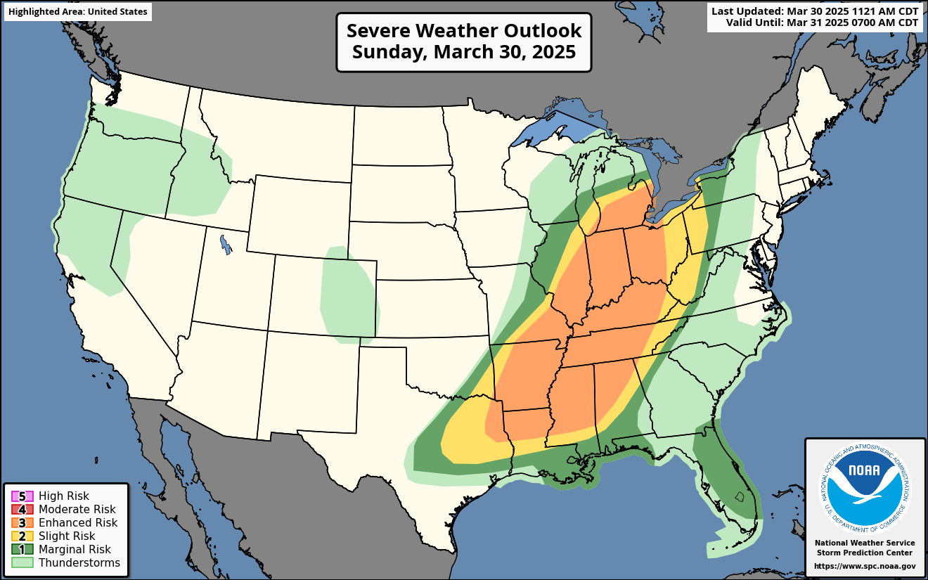
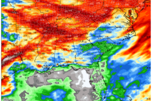
The overall severe weather setup today and tonight stretches from the Southern Plains through the Mississippi Valley and into the Southeast and Ohio Valley, including Alabama, with a broad area under threat for damaging winds, large hail, and tornadoes—including some that may be strong. A potent upper trough moving across the central U.S. is driving this active setup, with multiple shortwaves, a strengthening low-level jet, and rich Gulf moisture combining to support widespread severe convection in several distinct regions.
Ark-La-Tex to Mid-South:
This region will likely be the initial focus for explosive thunderstorm development this afternoon. Strong destabilization beneath steep mid-level lapse rates and strong deep-layer shear will foster the development of discrete supercells across northeast Texas, southeast Oklahoma, southern Arkansas, and northern Louisiana. These storms will have the potential for very large hail (up to 2-3 inches), damaging winds, and a few strong tornadoes. As we move into the evening, these storms are expected to grow upscale into one or more intense mesoscale convective systems (MCSs), which will sweep eastward into the Mississippi Valley and Southeast.
Mid-South and Tennessee Valley:
As the system evolves, the most concerning tornado potential may emerge during the early evening hours across parts of eastern Arkansas into western Tennessee, where forecast soundings indicate large, curved low-level hodographs and moderate to strong CAPE. This area lies on the nose of strengthening low-level winds, enhancing the risk for a few strong tornadoes. Storms will likely maintain a semi-discrete mode through the evening before gradually organizing into a squall line overnight, bringing an increasing threat for widespread damaging winds and line-embedded tornadoes from west to east.
Southeast U.S. including Alabama:
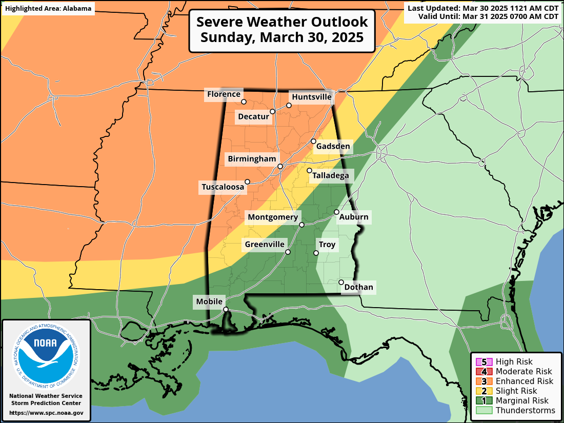
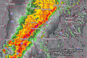
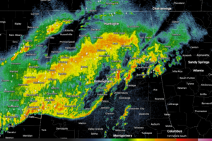
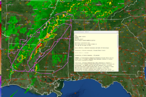
For Alabama and the Deep South, the main severe threat arrives overnight, beginning after midnight and continuing through Monday morning. The storms moving in from Mississippi are expected to organize into a squall line, capable of producing widespread damaging winds, hail, and embedded QLCS tornadoes. While instability will be somewhat lower during the overnight hours, high wind shear and forcing along the front will maintain the severe threat through the early morning hours. Ahead of the main line, some isolated strong to severe storms may develop during the afternoon, particularly if any pockets of heating occur. Rainfall totals of 1–2 inches are expected, with locally higher amounts that could result in isolated flooding across northwest Alabama.
Southwest Alabama/Northwest Florida This Afternoon:
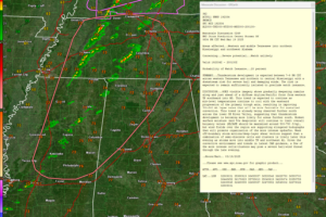
Across southwest Alabama and northwest Florida, a subtle boundary draped along the I-10 corridor has sparked early-day thunderstorms, with radar showing a few rotating cells embedded within the line—prompted by around 30 knots of bulk shear and curved low-level hodographs. This has created a brief window through noon for a potential tornado or two, especially in southern Mobile and Baldwin counties and into Escambia County, Florida. A tornado warning was just issued for part of Jackson County, Mississippi, just west of Mobile County, Alabama.
As we move into the afternoon, the threat transitions from spin-ups to flash flooding as upper-level diffluence enhances lift and storms begin training along the boundary. Rainfall totals of 3 to 5 inches, with locally higher amounts, could fall quickly, overwhelming low-lying, poor-drainage areas and creating flooding concerns through early evening. Storms should wane by sunset before a more organized severe threat arrives Monday morning.
Ohio Valley and Southern Great Lakes:
Farther north, including southern Illinois, Indiana, and Ohio, storms are likely to form along the cold front during the afternoon, aided by strong mid-level flow and daytime heating. While supercells could initially develop, storms will quickly organize into a line due to more meridional flow aloft. The primary threat here will be damaging winds, though large hail and a few tornadoes are also possible—especially in the earlier stages of storm evolution.
Florida Peninsula:
Finally, across Florida, a weaker system is in place today, but scattered afternoon thunderstorms may become strong to marginally severe, with damaging wind gusts and hail the primary threats. This activity is being driven by a mid-level impulse and daytime heating, with modest wind shear in place to support some organized multicell clusters.
Category: Alabama’s Weather, ALL POSTS, Severe Weather, Social Media
Page 2
 A powerful spring storm system will bring a widespread severe weather threat today and tonight from Texas to the Ohio Valley and into Alabama, with risks ranging from giant hail and damaging winds to a few tornadoes.
 A fast-moving squall line will sweep across Central Alabama late tonight into Monday morning, bringing a significant threat of damaging winds, embedded tornadoes, and heavy rainfall.
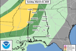
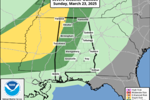
 A severe weather event is on the table for late Sunday night into Monday across Alabama, with the potential for damaging winds, large hail, and a few tornadoes—followed by a warm, summerlike pattern to close out March and start April.
 Some thunderstorms with heavy rain continue across parts of Central and North Central Alabama late tonight but the severe weather threat has greatly diminished.
 Strong storms with damaging winds and hail are expected to roll into Alabama tonight, bringing a classic springtime severe weather setup that needs your attention before bedtime.
 A few strong to severe storms are possible late tonight across northwest Alabama, but the greater threat remains west of the state from Texas to western Tennessee.
 A warm and breezy Sunday will give way to strong storms Sunday night, with the potential for damaging winds and hail across north and central Alabama.
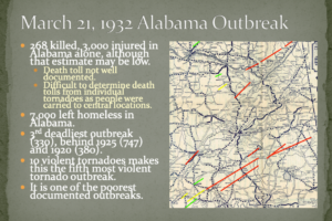 Remembering Alabama’s deadliest tornado outbreak that occurred on this date in 1932.
 The storms never really got going across Alabama and should just cause a few wind gusts to around 35-40 mph as they push east overnight.
 A line of heavy showers with gusty winds is pushing east across Alabama tonight. There is still a chance for isolated severe wind gusts for
 Severe storms remain possible tonight across northwest and north-central Alabama, with the main threats being strong winds, hail, and heavy rain.
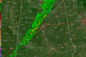
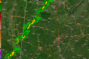
 Round two of our severe weather event has ended, leaving behind gusty winds, cooler temperatures, and at least two confirmed tornadoes in Calera and Winterboro, with survey teams investigating over a dozen additional damage tracks.
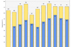 Sunday will bring cooler and drier conditions across Alabama, with highs in the mid-60s to low 70s and a few lingering clouds in the northeast.
 A significant tornado outbreak is expected across Alabama this afternoon and evening, with the potential for long-track tornadoes, damaging winds over 70 mph, and large hail as storms rapidly develop and move eastward.
